By Willy Blackmore
Word in Black
It’s no exaggeration to say that nearly all of LaPlace, Louisiana, flooded when Hurricane Ida hit the small town just upriver from New Orleans as a category 4 storm two years ago. Almost 60 percent of the 7,000 homes in the greater Saint John the Baptist Parish that are covered by the National Flood Insurance Program had to file a claim after the storm, which also left millions in southeastern Louisiana without power for upward of two weeks. It’s the kind of disaster that’s expected to happen again and again there in the future, according to an exhaustive new report from the Environmental Defense Fund and Texas A&M University.
Saint John the Baptist Parish faces the greatest climate-change risk of any county in the entire country. The parish also happens to be nearly 60 percent Black.
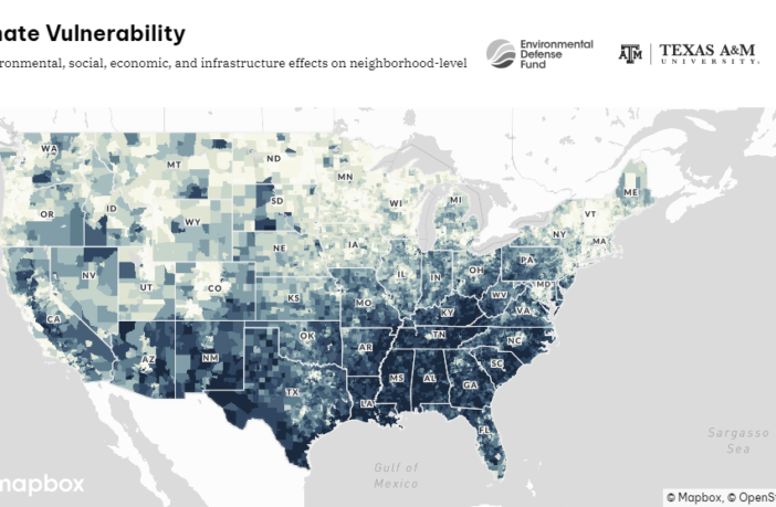
The Climate Vulnerability Index, as the new report and mapping tool is called, shows just how disproportionally at-risk such communities are to climate change. In the 10 most-threatened communities, the population is about one-third Black, although Blacks make up only 13.6 percent of the nation’s population. Half of those communities are in Louisiana, with locales in Texas, South Carolina and Kentucky rounding out the list. It’s just the latest stark reminder that the history of racism in the United States has concentrated Black people in places that will be hit early and hard by the climate crisis.
The Index draws from 184 different data sets to determine the climate risk of 70,000 census tracts across the country. It considers environmental risks (like flooding), socioeconomic matters (such as income and car ownership) and the availability of public resources, all of which affect how residents are able to respond to disasters. The Index also takes into account environmental pollution, a contributing factor in St. John the Baptist’s claim to the top spot: the parish is in Louisiana’s Cancer Alley, where practically every community ranks in the top 5 percent of the whole country for cancer risk from such pollution.
Sitting on a wedge of low-lying land between Lake Pontchartrain and the Mississippi River, LaPlace tends to be flooded from the lake side. During hurricanes and other severe weather patterns, storm-surge buildup on Lake Pontchartrain and high winds push water over the western bank and into the town.
After decades of delays, construction has begun on a levee that will protect the backside of the town, slated to be completed next year. But mitigating flood risk is only one piece of the overall puzzle in a community like St. John the Baptist Parish.
That’s where the Climate Vulnerability Index may be able to help. The tool is designed not only to show where the risks lie, but to help steer new investment in solutions. The Biden administration’s Inflation Reduction Act has made available “a historic level of funding” to build toward climate justice and equity,
Dr. Grace Tee Lewis, a senior health scientist at the Environmental Defense Fund said in a news release.
But the “right investments need to flow to the right places for the biggest impact.”
This article was originally published by Word in Black.


